

When Land Becomes a Determining Factor, Not Just a Formality
In the construction industry, attention often focuses on stunning architectural designs or the apparent strength of concrete and steel structures. However, there is one element that is rarely seen yet crucial for the safety of the entire building: the condition of the soil beneath it. Accurate geotechnical data is not just an administrative document to complete permits, but rather the foundation for decision-making that determines whether a structure will stand strong for decades or instead experience settling, cracking, or even collapse within months.
Unfortunately, many projects—both small and large scale—still treat soil investigation as a formality that is done hastily to cut costs and speed up schedules. In fact, misinterpretation of soil data at the early stages can lead to construction cost overruns that are much greater than the initial investment for thorough investigation. This is where the Building Information Modeling (BIM) approach adds value, as soil investigation can be digitally integrated into the building model, making geotechnical data no longer stand alone as a separate report, but a living part of the planning, design, and construction process.
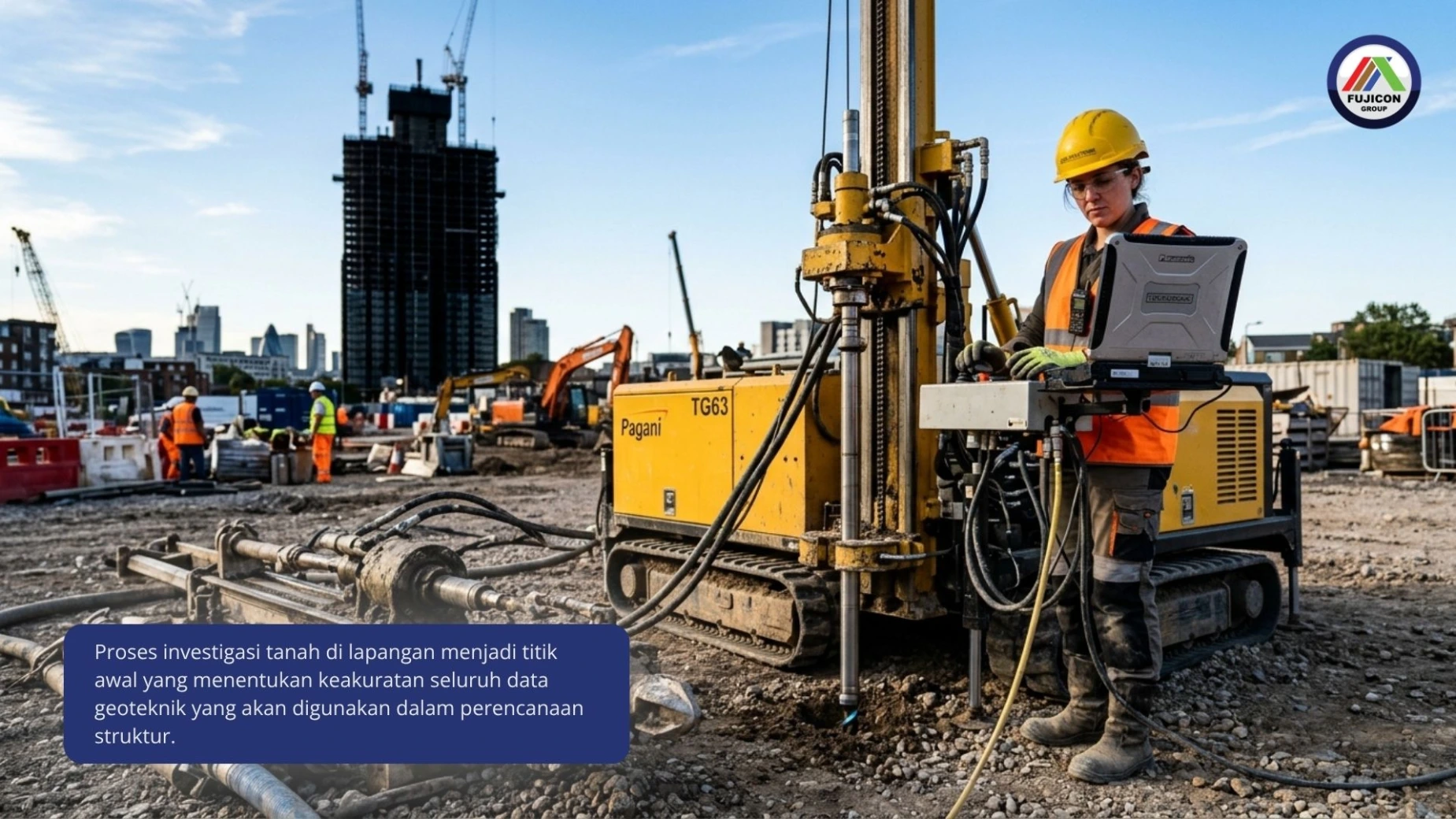
What is Soil Investigation and Its Position within the Scope of BIM
Soil investigation, or soil survey, is a series of activities aimed at understanding the characteristics of soil and rock layers at a specific location, including soil bearing capacity, layer types, groundwater depth, and potential risks such as liquefaction or soft soil that is prone to settlement. Within the scope of Building Information Modeling, soil investigation occupies a position often referred to as the GeoBIM discipline—a method that integrates conventional two-dimensional geotechnical data (boring logs, cone penetration test results, laboratory reports) into a three-dimensional model that can be accessed, analyzed, and coordinated with other disciplines such as structural, architectural, and MEP..
With this approach, the planning team no longer works with separate PDF geotechnical reports from the building model. Instead, each borehole, N-SPT value, and soil layer can be visualized directly within the BIM model, making it easier for structural engineers to see how the soil conditions at each point affect the foundation design. This reduces the risk of miscommunication between disciplines and accelerates the design validation process against the actual soil conditions in the field.
When Geotechnical Data is Ignored: Risks Lurking for Structures
Neglecting or simplifying the land investigation process can trigger various forms of structural failure that may not be immediately visible but develop over time. Some of the most common risks include:
- Differential settlement due to poorly mapped variations in soil bearing capacity causes buildings to tilt or crack in walls and columns.
- Foundation bearing capacity failure due to shallow foundation design applied on soft soil that actually requires deep foundations such as piles or bore piles.
- The potential for liquefaction during an earthquake, especially in saturated sandy soils that are not identified from the outset.
- Unanticipated groundwater infiltration disrupts the basement structure and incurs significant post-construction repair costs.
WARNING
Based on various studies of structural failures, most cases are not solely triggered by calculation errors, but rather by assumptions about soil conditions that do not match the actual conditions in the field. Minimal or unrepresentative geotechnical data is one of the root problems that is often overlooked since the planning stage.
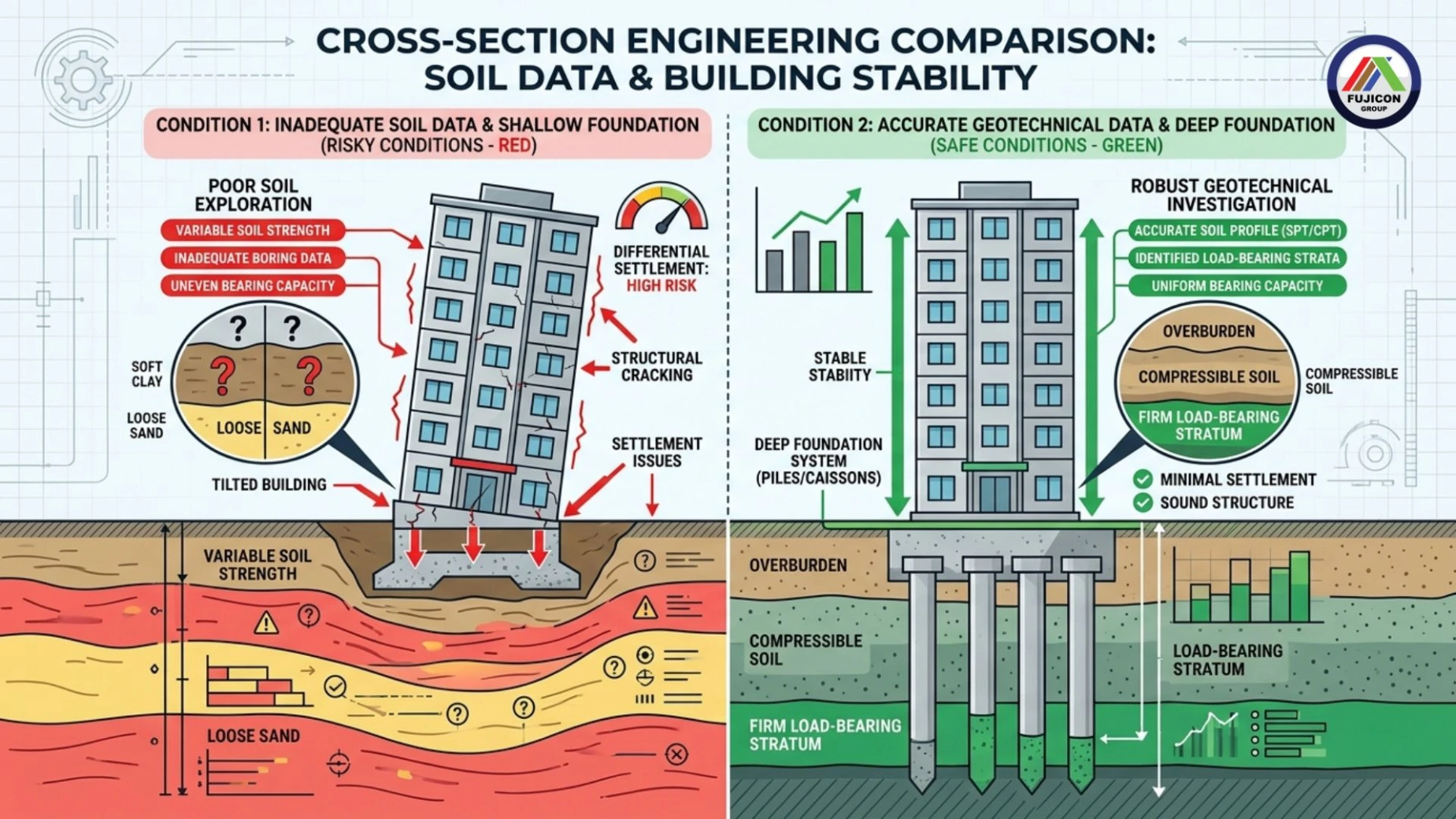
Perbandingan dampak desain pondasi tanpa data geoteknik memadai (kiri) dan desain yang didukung investigasi tanah menyeluruh (kanan) terhadap stabilitas jangka panjang bangunan.
Commonly Used Geotechnical Investigation Methods
To obtain representative soil data, the geotechnical team usually combines several investigation methods, both conducted directly in the field and through laboratory testing. Some of the most commonly applied methods in construction projects in Indonesia include:
- Cone Penetration Test (CPT): measures cone resistance and local soil friction to quickly and economically estimate soil bearing capacity.
- Deep Boring and Standard Penetration Test (SPT): soil sampling at various depths while simultaneously measuring the N-SPT value as an indicator of soil density and strength.
- Laboratory Testing: includes index properties tests, triaxial tests, consolidation, and direct shear tests to understand soil behavior under long-term loads.
- Geoelectric/Geophysical Survey: mapping subsurface layers over a wide area before determining more detailed test points.
- Groundwater Level Monitoring: important for basement planning, dewatering, and anticipating hydrostatic pressure on underground structures.
NOTES
The selection of the investigation method should be adjusted to the scale of the project, the type of structure, and the geological characteristics of the location. Projects with high structural loads or those located in earthquake-prone zones generally require a more comprehensive combination of methods compared to simple one- to two-story buildings.
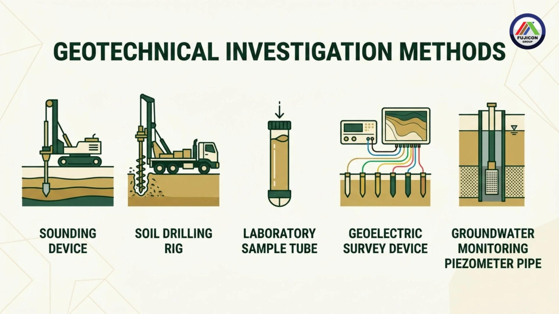
Ragam metode investigasi geoteknik yang umum dikombinasikan untuk memperoleh gambaran menyeluruh mengenai karakteristik tanah suatu lokasi proyek.
Integrating Geotechnical Data into BIM Models
After the field data and laboratory results are collected, the next stage that distinguishes the conventional approach from the BIM-based approach is the process of integrating that data into a three-dimensional model. Borehole points, soil layer profiles, and bearing capacity values are mapped as geospatial objects within the model, allowing them to be analyzed alongside structural elements such as foundations, pile caps, and basements.
Through this integration, structural engineers can directly see which points have low load-bearing capacity, which areas are at risk of uneven settlement, and how the foundation design needs to be adjusted in each zone. The clash detection process typically used to detect collisions between structural elements and MEP can also be extended to check the suitability of the foundation design against actual soil conditions, long before construction begins.
"The earlier land data is understood and integrated into building models, the less room there is for erroneous assumptions to develop into structural failures later on."
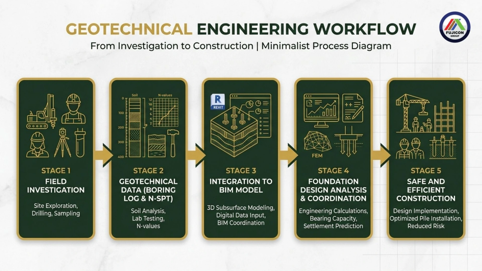
Alur kerja integrasi data geoteknik ke dalam model BIM, dari investigasi lapangan hingga keputusan desain pondasi yang lebih tepat.
Real Benefits of Accurate Geotechnical Data for Construction Projects
Investment in thorough land investigation and the integration of its data into BIM provides benefits that far exceed mere compliance with technical standards. Among its main advantages are construction cost efficiency, as the correct foundation design from the outset prevents cost overruns due to repairs or structural reinforcements later on. Additionally, design decisions become more precise, as the structural team works based on actual data rather than overly conservative assumptions or overly optimistic ones.
Another often-overlooked benefit is the acceleration of the coordination process among disciplines. When geotechnical data is integrated into a single BIM model that can be accessed collectively, the architecture, structural, and MEP teams can discuss based on the same reference, reducing back-and-forth revisions due to differing interpretations of data. Ultimately, this approach also supports project sustainability, as designs that align with actual soil conditions reduce the need for excess materials and the risk of failures that impact the surrounding environment.
INSIGHT
The cost of comprehensive geotechnical investigations generally only accounts for a small portion of the total project value, but its impact on long-term safety and efficiency is much greater than the investment value. Neglecting this stage can potentially lead to much higher repair costs.

Conclusion: Accurate Geotechnical Data, the Foundation for Safe Structures
Structural failures rarely occur due to a single cause; however, the root of the problem can often be traced back to the earliest stages of a project: how accurate and comprehensive the geotechnical data used for design decisions is. Soil investigation is not merely a supplement to the permitting documents, but rather a scope of BIM work that determines the reliability of the entire building model constructed upon it. By integrating soil data into a three-dimensional model, the project team gains full visibility of the risks hidden beneath the surface, allowing for foundation design decisions to be made more accurately, efficiently, and safely.
Ultimately, reducing the risk of structural failure is not just about avoiding financial losses, but also about ensuring the safety of everyone who will use the building for years to come. Investing in the right geotechnical data, managed professionally and integrated within the BIM ecosystem, is a crucial first step that should not be compromised in any construction project.
Realize Safe Projects Together with Fujicon Priangan Perdana
As the best BIM Consultant, Fujicon Priangan Perdana is ready to help ensure that the geotechnical data and soil investigation of your project are managed accurately and fully integrated into the BIM model, from the planning stage to construction.
📱 WhatsApp: +62 811 2227 5222
🌐 Website: bimsolusi.fujicon.id